


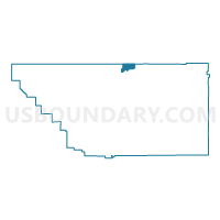
Voting District 10925, Kern County, California
About
Outline

Summary
| Unique Area Identifier | 531744 |
| Name | Voting District 10925 |
| County | Kern County |
| State | California |
| Area (square miles) | 37.66 |
| Land Area (square miles) | 37.59 |
| Water Area (square miles) | 0.06 |
| % of Land Area | 99.83 |
| % of Water Area | 0.17 |
| Latitude of the Internal Point | 35.75850010 |
| Longtitude of the Internal Point | -118.65461880 |
Maps


Graphs
Select a template below for downloading or customizing gragh for Voting District 10925, Kern County, California


Neighbors
Neighoring Voting District (by Name) Neighboring Voting District on the Map
- Voting District 10000, Kern County, CA
- Voting District 10045, Kern County, CA
- Voting District 10050, Kern County, CA
- Voting District 10920, Kern County, CA
- Voting District 55290, Tulare County, CA
- Voting District 55435, Tulare County, CA
Top 10 Neighboring County Subdivision (by Population) Neighboring County Subdivision on the Map
Top 10 Neighboring Elementary School District (by Population) Neighboring Elementary School District on the Map
- Kernville Union Elementary School District, CA (11,432)
- Ducor Union Elementary School District, CA (1,276)
- Linns Valley-Poso Flat Union School District, CA (612)
- Blake Elementary School District, CA (169)
Top 10 Neighboring Secondary School District (by Population) Neighboring Secondary School District on the Map
- Kern Union High School District, CA (596,351)
- Porterville Unified (9-12) School District, CA (47,072)
Top 10 Neighboring State Legislative District Lower Chamber (by Population) Neighboring State Legislative District Lower Chamber on the Map
- Assembly District 32, CA (547,084)
- Assembly District 30, CA (504,729)
- Assembly District 34, CA (487,193)